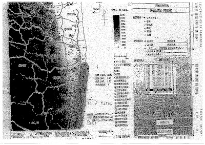
TEPCO's Tokyo headquarters did the simulation clearly using their own software, faxed the results back to the plant who then faxed those maps, along with the plant status data and radiation monitoring data (as much as they could get at that time) to:
The Minister of Economy, Trade and Industry;
Governor of Fukushima Prefecture;
Mayors of Ookuma-machi and Futaba-machi.
The simulation is in the 11,000 documents that the Nuclear and Industrial Safety Agency, regulatory agency for the nuclear industry under the METI, suddenly decided to dump onto the public on June 24, after NHK somehow obtained part of the documents and made a news story out of it on June 22. (The news story linked is in Japanese. More later.)
TEPCO was assuming the release of noble gas (xenon, krypton, probably) and iodine. This map is one of the several that was sent out by fax, and the simulation date and time was March 11, 2011 at 11:50PM, assuming the release of radioactive materials from the exhaust tower for the Reactors 1 and 2. This map is on page 10 of the March 12 file that NISA dumped on June 24.
The release of radioactive materials was based on the assumptions as follows (handwritten note on page 6 of the March 12 file released by NISA):
Secondary [?] vent of the Reactor 2 Dry Well
"Severe Accident" with fuel damage
Capacity of Dry Well plus Suppression Chamber = 6930 cubic meters
Pressure dropping from 8 atmospheric pressure to 1 atmospheric pressure
Wind direction: north by northeast
Wind speed: 1.2 meter per second
Atmospheric stability: F [no idea what that means; "fair"?]
Amount of radiation and direction:1 hour after the release: noble gas 26 mSv, SE 0.28 km
3 hours after the release: 50 mSv, S 4.29 km
5 hours after the release: 50 mSv, S 4.29 km
So, TEPCO assumed from the beginning that it was a "severe accident".
The simulation was for the body dose equivalent internal radiation for adults for the total of 18 locations, but it is hard to see on the map as it was faxed multiple times before it was scanned.
Fukushima I Nuclear Power Plant faxed this map to the above recipients at 3:35AM JST, March 12, 2011.
At the bottom, it looks to me to be saying "amount of noble gas released: 6.01E+17 becquerels", or 6.01 x 10^17, or 601,000,000,000,000,000 becquerels or 601,000 terabequerels.
We know that the Ministry of Economy, Trade and Industry and the NISA sat on these maps, the Fukushima prefectural government sat on them, and TEPCO didn't release them as it was not in their capacity to release to the general public. The company released them to the affected municipalities, or at least 2 of them.
Okuma-machi and Futaba-machi acted on the data, and informed the residents to evacuate using the emergency broadcasting system. We weren't told back then that the towns had this information when they evacuated the residents.
If you recall, it was only in mid May that the government decided to release the early simulations by SPEEDI.
The NISA would probably have continued to sit on them if it were not for the NHK news story.
So, where's the outrage in Japan against their government? I see a lot of anger against TEPCO, but the evidence suggests that the anger should be directed far more to the government.
